
.png)
Understanding Addresses in Cali, Colombia: A Guide for Visitors
- Juan from Cali Cultural Tours
- Feb 17
- 4 min read
Updated: Feb 25
Navigating addresses in Colombia can be a bit confusing for visitors, especially those used to street names instead of a structured numbering system. In Cali, as in most Colombian cities, addresses follow a logical pattern but require some understanding to use effectively.

The Basic Structure of Addresses in Cali
Colombian addresses do not typically use street names; instead, they follow a numerical system. A standard address in Cali is structured as follows:
EXAMPLE: Calle 15 # 67-51
SECTION 1: before the #.
SECTION 2: between # and -.
SECTION 3: after the -.
Breaking it down:
SECTION 1: Calle (Street) 15 – This indicates the road (Calle or Carrera mainly) that the front door of your property is on.
SECTION 2: # 67 - This number is the Carrera or Calle intersecting the road mentioned on section 1. Thus, you now have a COORDINATE.
SECTION 3: -51 – is the (aproximate) distance in meters from that intersection to the front door of the property. All even numbers are on one side, all odd numbers are on the other side.

The number after the hash symbol (# SECTION 2) is crucial in pinpointing a location, as it is the nearest intersecting street. SECTION 3 is the specific building’s distance along SECTION 1's street. For example, Cra. 40 # 5-25 means the building is located on Carrera 40, and it is approximately 25 meters away from the intersection with Calle 5.
Instead of names, streets are designated as either Calles (Cll.) or Carreras (Cra. Cr. Kr. Kra.), forming a grid system that makes it relatively easy to logically locate a destination once you understand the numbering. However, some main avenues do have specific names.
Calles and Carreras: How They Work
Calles (Cll.) run (in Cali) vertically from north to south and south to north, perpendicular to Cali river. The first Calle (Calle 1) is known as Avenida de Los Cerros (Avenue of The Hills), and Calles increase in number towards the East. Avenida de Los Cerros marks the base of the west hills of Cali. Calles west of The Hills avenue have an 'O' or 'Oe' for 'Oeste' (west), indicating they are on the west side of Avenida de Los Cerros, and they increase in that direction as well.
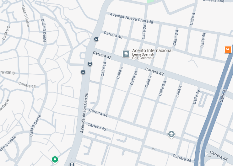
Avenida de Los Cerros is Calle 1, to the West they grow with Oeste. Carreras (Cra.) run horizontally from west to east, east to west, parallel to the river. Cali river marks the beginning for numeration of Carreras. South of the river, you have Carrera 1 (also known as Avenida Colombia or Avenida Uribe Uribe). North of the river, Carreras will have an 'n', 'N', 'Norte' or 'norte' indicating they're on the north side of the river. Most Carreras in the north are Avenidas.

Avenida Colombia is Carrera 1. Avenidas (Av.) are major roads, and some are also labeled as Calles or Carreras but are more significant in traffic flow.
Transversales and Diagonales are additional variations in street designations, though less commonly used in the city grid.
The Autopista is an expressway, the largest single road in Cali, both in length and width. Multiple lanes, few traffic lights and intersections.
Letters are usually used for smaller or shorter roads that only go for a couple of blocks, i.e.: Calle 1a, Carrera 34b.
Special Cases and Exceptions
While the system is generally straightforward, some neighborhoods have their own layouts, especially in:
Older districts, where street numbers might not follow the grid as strictly.
Gated communities and residential complexes, which may use internal numbering systems different from city street numbers.
Rural areas, where addresses often include references to landmarks instead of exact numbers.
Tips for Finding an Address in Cali
In this complex system with so many moving parts, modern transportation apps like Google Maps, Waze or Uber easily get lost (and get you lost). There are so many moving parts to an address:
Cra. 40 # 5-25
Cra 40 # 5-25
Carrera 40# 5-25
Kra 40 # 5 - 25
Kr. 40 # 5 -25
You never know how to write it, and you never know how Google Maps is going to undersand it, and you never know where it's going to send you to. So:
RECOMMENDATIONS:
In order to not get lost, my personal hierarchy is:
NAME OF THE PLACE: usually Uber and ride sharing apps get the names from Google Maps. If your place has an actual name on it, then use it. Names of nearby shops or businesses can be very useful.
ALWAYS IF POSSIBLE: get the pin location of the place. If you need to input it on Uber, try to manually put the pin location on the map.
LAST RESOURCE: always use the address only as a last resource. Caleños (Cali people) however will very easily be able to read an address.
Final Thoughts
Understanding how addresses work in Cali can help you move around the city more confidently. While it may seem complex at first, once you get used to the numbering system, it actually makes navigation quite efficient. Whether you're visiting a restaurant, booking an Airbnb, or taking a taxi, knowing how to interpret an address will make your time in Cali much smoother!